
Thursday, 7 September

But we had some walking to do, and finally, as was now the custom, Claudia and I blazed the trail. Sans map. And wouldn't you know it: for the first time in four days hiking, the trail was sans blaze. We were fifty meters from the hotel and in danger of getting lost already. But there were no other likely looking paths, and this path looked likely: it was well worn, in roughly the right spot, and roughly the right direction. Downhill. Thomson's rule of hiking: if you are going to make a mistake, you'll make it by going downhill. (Or: if it looks easy, it's the wrong way.) But Murphy was being distracted, and fifteen minutes of steep descent through the tall pines and bracken brought us to a junction with a blazed path following the contour around the hill as advertised. The next hour or so was a very pleasant walkthrough the forest as the path meandered back and forth along the side of the hill. For the first time, we were miles ahead of schedule when the blazes indicated the turn up the hill to the Col de St Pierre (1452 m). So much so that I was concerned that this was not in fact the col. It didn't look very high either, but we'd been fooled by that before. Sure enough though, we were there and that was it. I think cols are my favorite spots. They do not have the three sixty degree panorama of a mountain top, but seeing both sides of the mountain is nearly the same, and cols lack the feelings of vertigo, agoraphobia, and cold that characterized peaks for me. This col was small, and easily accessible, but it was no exception. The view was spectacular. And as usual, part of the view was confirmation that the sunshine we had been enjoying had been in the previous valley only. If we wanted to swap sides, which we did, then we were going to have to put up with weather.
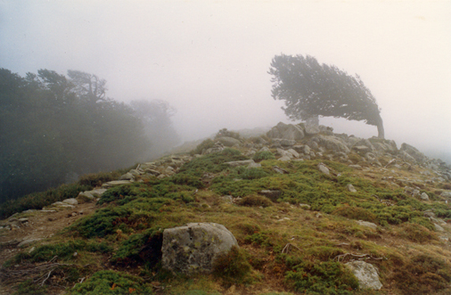
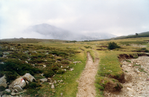
We turned to follow the ridge. Yes, the reason the col had been so easy was because it was just the beginning of the climb, there were another four hundred meters to go yet. There were no trees on this part of the ridge, and so no protection from the cold wind and mist that billowed up from the valley below. In ten minutes we had gone from Schwarzwald to Brontë country: bleak and windy, misty and cold. A tree, bent by persistent wind into a permanent, almost horizontal curve, loomed out of the mist to complete the picture.
Figure 20: Withering Heights
The trees came and went, the sun went, and the cold damp conditions, pushing past the shoulder-high shrubbery reminded me of the second day a little too much. But it did not last long. We stopped for our usual pit stop, scarfed some gorp, and the map came past, with Martha and Alfie hot on its heels. We were very close to the top, and only twenty minutes or so from our tentative lunch spot, Lac de Nino. Alfie had been looking forward to the lake as one of the high spots on the trip. They pressed onto save us a seat. The smooth, flat, bald top of Bocca Reta (1883 m), complete with a path worn deep through the soft peat, reminded me incredibly of the Pennines. In places the path was worn so deep and narrow (presumably sheep were the chief users) that it was often easier to walk beside rather than in it.
Figure 21: Sheep/hiker path cut through the peat
Suddenly we could see the lake. It was a little disappointing, since the reflected gray skies made it look more like a murky puddle in the middle of a field, than the blue mirror in a sea of green that the postcards had depicted. No matter, it was a good sight, resplendent with cattle and horses roaming free throughout the grassy valley.
We followed the path down to the level of the lake, and then walked along beside it until we caught up with our fellow diners. They were not happy with the table they had chosen, the wind was just too cold to sit out in. We found a more sheltered spot in the lee of a patch of maquis bushes. Our four-legged companions also appeared to favor the spot. The smell was quite pungent, and we had to be careful where we sat.